美国地震风险图
版主: resso
-
fortyNiner

- 中坚
- 帖子: 655
- 注册时间: 2023-12-21
- Has thanked: 5 time
- Been thanked: 47 time
Re: 美国地震风险图
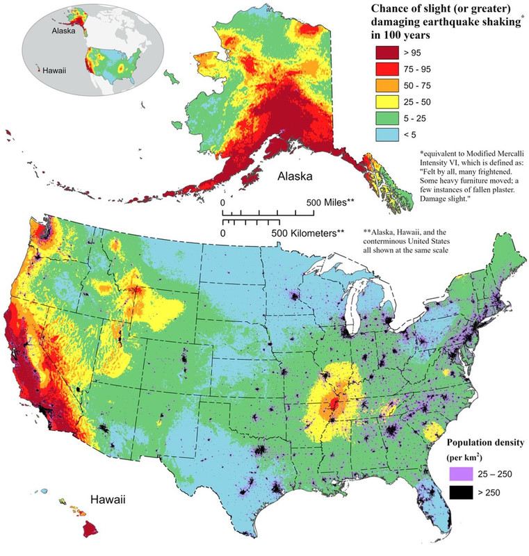
I can foresee a new plate boundary emerging at the corner of Missouri, Arkansas and Tennessee, and it will spread northeast to Lake Erie and Lake Ontario and finally join St Lawrence River. To the south, it might follow the Mississippi River. Give it 50 million years, the US will be on both side of an ocean.

-
fortyNiner
- 中坚
- 帖子: 655
- 注册时间: 2023-12-21
- Has thanked: 5 time
- Been thanked: 47 time
Re: 美国地震风险图
Yeah, if earthquake risk is your main concern.
However, other areas have their risks too.
Taking them all into consideration, the West might have lower natural disaster risk per capita than the East.
Re: 美国地震风险图
美国历史上最大的马德里地震就发生在那里。那是北美版块的应力中心。
fortyNiner 写了: ↑21 1月 2024, 16:19I can foresee a new plate boundary emerging at the corner of Missouri, Arkansas and Tennessee, and it will spread northeast to Lake Erie and Lake Ontario and finally join St Lawrence River. To the south, it might follow the Mississippi River. Give it 50 million years, the US will be on both side of an ocean.
陛下,您设计的军舰威力无比、坚固异常并且十分美丽,堪称空前绝后。它能开出前所未有的高速度,它的武器将是世上最强的。舰内设施将使从舰长到见习水手的全部乘员都会感到舒适无比。这艘辉煌的战舰看起来只有一个缺点:只要它一下水,就会立刻沉入海底,如同铅铸的鸭子一般。
-
fortyNiner
- 中坚
- 帖子: 655
- 注册时间: 2023-12-21
- Has thanked: 5 time
- Been thanked: 47 time
Re: 美国地震风险图
Well, maybe the term "per capita" is not the right one to use when assessing natural disaster, but I believe they do have something similar.
If you add all the deaths due to natural disasters the last hundred years, you can find the risk. However, a powerful quake might wipe out the population of a big city with 1 million, but it kills only one person when it hits a remote area and that person is the only one there. But that does not mean the quake risk is a million times higher in that city than in that remote area. That's why I used the term "per capita". I am sure they adjust appropriately when assessing the risk.
Anyway, if you look at the risk from all natural disasters combined, the West might not have higher than the East.
mi6 写了: ↑21 1月 2024, 16:33Oh yeah, simple math huh?
- this is the first time I heard somebody using per capita data to assess natural disaster risk.
fortyNiner 写了: ↑21 1月 2024, 16:25Taking them all into consideration, the West might have lower natural disaster risk per capita than the East.
上次由 fortyNiner 在 21 1月 2024, 16:57,总共编辑 3 次。
-
fortyNiner
- 中坚
- 帖子: 655
- 注册时间: 2023-12-21
- Has thanked: 5 time
- Been thanked: 47 time
Re: 美国地震风险图
Yes, it's a weak spot. It might break and tip the balance.
牛大春 写了: ↑21 1月 2024, 16:28美国历史上最大的马德里地震就发生在那里。那是北美版块的应力中心。
fortyNiner 写了: ↑21 1月 2024, 16:19I can foresee a new plate boundary emerging at the corner of Missouri, Arkansas and Tennessee, and it will spread northeast to Lake Erie and Lake Ontario and finally join St Lawrence River. To the south, it might follow the Mississippi River. Give it 50 million years, the US will be on both side of an ocean.
Re: 美国地震风险图
是的。那个点往北是加拿大地盾,地球上最稳固的克拉通之一。往南的美国南部是后来融合上去的。
陛下,您设计的军舰威力无比、坚固异常并且十分美丽,堪称空前绝后。它能开出前所未有的高速度,它的武器将是世上最强的。舰内设施将使从舰长到见习水手的全部乘员都会感到舒适无比。这艘辉煌的战舰看起来只有一个缺点:只要它一下水,就会立刻沉入海底,如同铅铸的鸭子一般。